
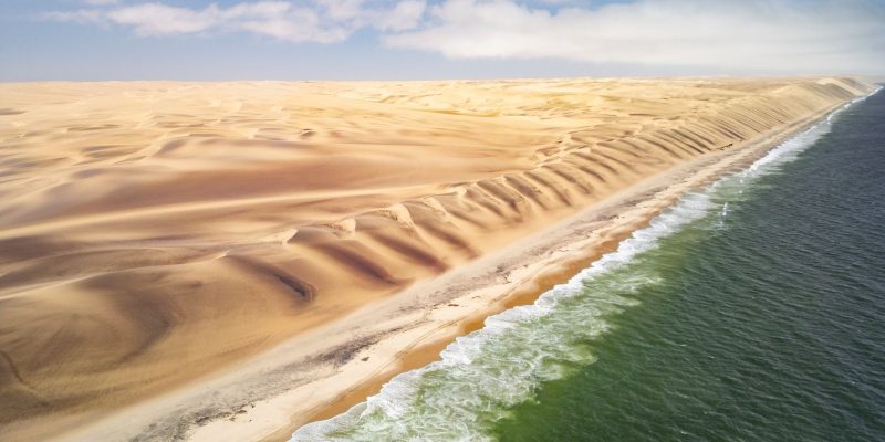
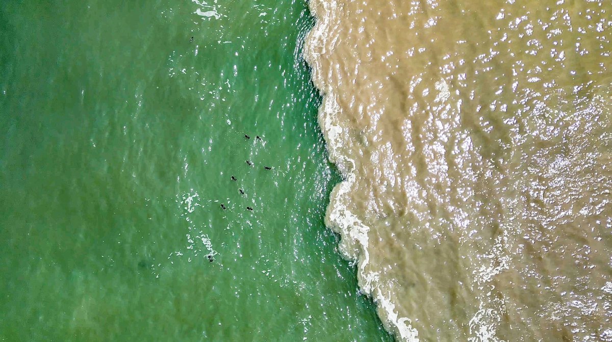
Fly along the western edge of Angola’s Iona National Park and the geography does something that should not be possible. The dunes of the Namib, one of the driest places on Earth, run west until they stop at a strip of wet sand a few hundred meters wide, and then the Atlantic begins. No estuary, no marsh, no gradual handover. And the water on the other side of that line is not blue. It is a cold, opaque green.
That color is the whole story. In an article published on October 28, African Parks set out why 160 kilometers of coastline on a desert park matters, through an assessment by Iona’s Conservation Manager, Miguel Lajas.
A desert park with an ocean problem
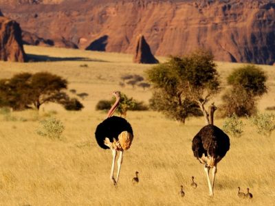
Iona covers 15,150 square kilometers of dune, gravel plain and ancient Welwitschia in Angola’s Namibe province. It is the country’s oldest and largest national park, it runs up against Namibia’s Skeleton Coast National Park across the border, and it has been managed by African Parks in partnership with the Angolan government since December 2019.
It gets filed, reasonably enough, as a desert park. But roughly 160 kilometers of its western boundary is Atlantic coast, and it is the only stretch of coastline in African Parks’ portfolio that sits inside the influence of the Benguela Current.
Why is the water green?
Along south-western Africa’s Atlantic coast, the wind blows from the south for most of the year. Crucially, it blows parallel to the shore rather than onto it, and as it does, it drags the surface water away from land and out to sea.
Something has to replace that water, and the replacement comes from below: cold water carrying nutrients that have spent years sinking out of the sunlit layer. Oceanographers call the process upwelling, and the useful way to picture it is a pump that returns the ocean’s own fertilizer to the depth where light reaches it and plankton can use it.
Everything else queues up behind the plankton. Small fish eat it, larger fish eat them, and seabirds, seals and the whales passing offshore eat those. The green in the water is the pump running, visible from the air.
There are only four of these on the planet
Systems like this are called Eastern Boundary Upwelling Systems, and there are four major ones: the California Current, the Humboldt off South America, the Canary off north-west Africa, and the Benguela, which runs up the coasts of South Africa, Namibia and Angola.
Between them those four cover less than one percent of the world’s ocean surface. They produce up to 20 percent of all the fish caught in the world’s oceans. Iona’s coast sits inside that one percent, at the very top of the Benguela, where the cold northbound water meets warm tropical water coming down from the north.
Stated that way, a park best known for sand dunes turns out to hold a piece of one of the four most productive marine systems on Earth.
The river that should not be there
The Cunene reaches the Atlantic at Iona’s southern boundary, where the park meets the Skeleton Coast. Along thousands of kilometers of hyper-arid Namib coastline, only two rivers reach the sea and keep flowing year-round: this one, and the Orange, roughly 1,300 kilometers to the south.
What that produces is a wetland in the middle of a desert coast. Fresh and brackish water meet open ocean within a few hundred meters, and the river adds its own nutrient load to a stretch of sea that is already among the most productive anywhere. The result is a small area doing far more work than its footprint suggests: feeding and breeding habitat for migratory and coastal birds, a nursery and spawning ground for fish, and a feeding ground for marine megafauna offshore.
It works in the other direction too. For the oryx, springbok, black-backed jackal and brown hyaena that range this coast, the Cunene is a linear oasis, a permanent thread of water running through a landscape where almost all water is seasonal. Brown hyaena, worth noting, is listed by the IUCN Red List as Near Threatened. We are giving the category alone, because the Red List’s species pages returned an access error from both machines we check from on the day this was written and we do not print an assessment date or population figure we have not opened and read.
Does any zoo or aquarium fund this work?
We looked, and we did not find one. African Parks publishes a strategic funding partners page, a government partners page and a general partners page, and across all three the named supporters are private foundations, family philanthropies, the Dutch Postcode Lottery, the European Union, the Elephant Crisis Fund and corporate partners. Not one accredited zoo or aquarium appears on any of them.
Iona’s own named partner is the Angolan government: African Parks signed a long-term management agreement with Angola’s National Institute of Biodiversity and Conservation Areas in late December 2019, with the handover ceremony on January 31, 2020.
That is a real finding rather than a gap. The AZA reported that in 2025 its 235 accredited and certified facilities spent approximately $372.4 million on conservation work across 139 countries, and some of that money lands in African field programs. None of it is documented as landing here, and we are not going to imply otherwise. African Parks’ conservation finance work is, instead, being built on other instruments, which we covered when the organization moved to get paid for every square kilometer that stays intact.
What is still unknown
The honest headline on Iona’s coast is how little of it has been surveyed. African Parks frames the piece around how much there is still to discover, which is an unusual thing for an organization to publish about its own flagship landscape and a good reason to pay attention to what comes out of it next.
For a visitor, the appeal is simpler and does not require a research permit: a place where you can stand on a dune, walk a few hundred meters, and put your feet in one of the four richest bodies of water on the planet. The full assessment is on African Parks’ stories page.
Quick answers
- How big is Iona National Park?
It covers 15,150 square kilometers of dune, gravel plain and ancient Welwitschia in Angola's Namibe province, and it is the country's oldest and largest national park. Roughly 160 kilometers of its western boundary is Atlantic coastline.
- What is upwelling?
Wind blowing parallel to a coast drags surface water out to sea, and cold, nutrient-rich water is drawn up from below to replace it. The effect is a pump that returns nutrients to the sunlit layer where plankton can use them, which is why the water off Iona looks green rather than blue.
- How many major upwelling systems are there?
Four. The California Current, the Humboldt off South America, the Canary off north-west Africa, and the Benguela, which runs up the coasts of South Africa, Namibia and Angola. Together they cover less than one percent of the world's ocean surface and produce up to 20 percent of the global fish catch.
- Why does the Cunene River matter?
Along thousands of kilometers of hyper-arid Namib coast, only two rivers reach the sea and keep flowing year-round: the Cunene and the Orange, about 1,300 kilometers to the south. The Cunene creates a wetland on a desert coastline and a permanent water source for the oryx, springbok, jackal and brown hyaena inland.
- Who manages Iona?
African Parks, in partnership with the Angolan government. The long-term management agreement was signed with Angola's National Institute of Biodiversity and Conservation Areas in late December 2019, with a handover ceremony on 31 January 2020.
- Do any zoos or aquariums fund this work?
Not that we could verify. We checked African Parks' strategic funding partners page, its government partners page and its general partners page. The named supporters are private foundations, family philanthropies, the Dutch Postcode Lottery, the European Union, the Elephant Crisis Fund and corporate partners, and no accredited zoo or aquarium appears on any of them.