
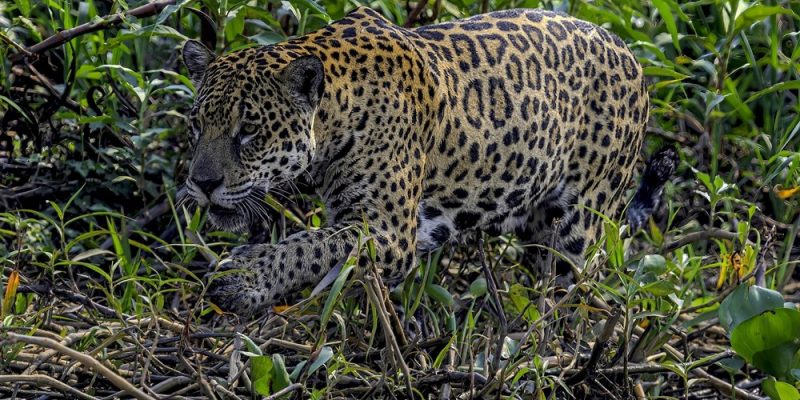
For decades the map of where jaguars can still travel across the Americas was drawn largely from expert judgment: biologists who knew a landscape saying which valley or river margin an animal could probably use. A study published on October 15, 2026 in the journal Ecosphere redraws that map from the animals themselves, using more than 134,000 GPS locations collected from 99 adult jaguars in five countries.
It is the first range-wide assessment of jaguar connectivity built on recorded jaguar movement rather than on expert opinion alone, and the Wildlife Conservation Society, which runs the Bronx Zoo, led it.
What connectivity means, and why a cat needs it
Connectivity is the degree to which an animal can get from one population to another without being stopped by a highway, a soy field, a city or a stretch of country where it will be shot. It matters for a species like Panthera onca, the largest cat in the Americas, because isolated populations slowly lose genetic variety, cannot recolonize ground where the species has been wiped out, and have nowhere to go when the climate shifts underneath them. Jaguars have already disappeared from more than half of their historic range over the past century, through habitat loss, fragmentation, infrastructure and conflict with people.
“Connectivity is fundamental to the long-term survival of jaguars,” said Harshad Karandikar, the study’s lead author and a WCS conservationist. “Using GPS movement data from jaguars across their range allowed us to identify areas that are most likely to support movement between populations. Some of the corridors we identified align with previous conservation priorities, while others suggest new opportunities to maintain connectivity before it is lost.”
The corridors the collars found
The analysis identified major connectivity zones across Central America, the Amazon Basin and southern South America. The single most significant find was a corridor running from northern Bolivia through the Pantanal and the Paraguay River region into Paraguay and northern Argentina. The work also pointed to new potential connections in parts of Central America.
The uncomfortable half of the result is the other direction. In some places the corridors that conservation planning has assumed for years appear not to match what the landscape looks like now. A hypothesis about where animals could move, written before the roads and the clearing arrived, can quietly stop being true, and nothing announces it.
Allison Devlin, who directs the jaguar program at the wild cat organization Panthera and is quoted in the announcement, framed the map as a blueprint rather than a conclusion. She pointed to the Bi-National Corridor between Honduras and Guatemala, the Amazon-Pantanal Corridor in Brazil, and Colombia’s A2O Corridor as areas the results flag for more attention.
“Connectivity maps show us where jaguars can move and what barriers may stand in their way, but the real test is what happens on the ground,” said Robin Naidoo, a co-author and lead scientist at WWF-US. “By combining range-wide mapping with field research, we can see which corridors are being used, where connections are breaking down, and where restoring habitat could help put those connections back together.”
What happens to a map like this
The authors are careful about what the work is. The newly identified corridors are candidates, not confirmed routes, and the researchers say they need checking on the ground through camera trapping, genetic analysis, environmental DNA surveys and local ecological knowledge. The map tells you where to go and look. It does not tell you that a jaguar walked there last Tuesday.
The other finding with teeth is jurisdictional. Many of the corridors the study identified lie outside protected areas, on working land. That makes the conservation question a planning question, about land use, restoration and the other arrangements that keep habitat intact in places nobody is going to turn into a national park.
“Jaguars are telling us something important about the condition of the landscapes they inhabit,” said Luke Hunter, executive director of the WCS Big Cats Program. “When connectivity is lost, populations become isolated and more vulnerable to decline. Protecting corridors is not just about conserving jaguars, it is about maintaining the ecological processes that sustain entire ecosystems across the Americas.”
For the zoo side of the Wildlife Conservation Society, this is the quieter half of an institution better known for what is on exhibit in the Bronx, where a snow leopard cub went on view at the end of September, and where a river otter turned up in the Bronx River after a century away. The jaguars are another kind of exhibit entirely: 99 animals, five countries, and a line on a map that an actual cat put there.
Source: Wildlife Conservation Society.
Quick answers
- What did this study actually do?
It analyzed more than 134,000 GPS locations recorded from 99 adult jaguars in five countries to produce the first range-wide assessment of jaguar connectivity built on recorded animal movement rather than on expert opinion alone.
- What is connectivity?
The degree to which an animal can get from one population to another without being stopped by a road, a field, a city or a stretch of country where it will be killed. Without it, populations lose genetic variety, cannot recolonize lost ground, and have nowhere to go when conditions change.
- Which corridor was the biggest finding?
A corridor running from northern Bolivia through the Pantanal and the Paraguay River region into Paraguay and northern Argentina. The study also identified new potential connections in parts of Central America.
- Did the study find anything had been lost?
Yes. In some places the corridors that conservation planning has assumed for years appear not to match current landscape conditions, which suggests some historically important connections may already have gone.
- Are these corridors confirmed?
No. The authors describe them as conservation priorities that require field validation through camera trapping, genetic analysis, environmental DNA surveys and local ecological knowledge.
- Who led the work?
Harshad Karandikar, a conservationist at the Wildlife Conservation Society, with an international team. Co-authors quoted in the announcement include Robin Naidoo of WWF-US and Allison Devlin of Panthera.
- How much range have jaguars lost?
Jaguars have disappeared from more than half of their historic range over the past century, through habitat loss, fragmentation, infrastructure development and conflict with people.